About City hiking paths
This app is your companion on the Vienna city hiking trails. Here you get the exact route of the city hiking trails in Vienna's green belt. All hiking trails offered by the Forestry Office and the Agricultural Business of...
This app is your companion on the Vienna city hiking trails. Here you get the exact route of the city hiking trails in Vienna's green belt.
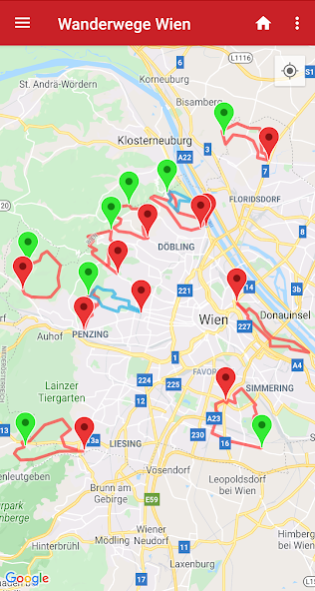
All hiking trails offered by the Forestry Office and the Agricultural Business of the City of Vienna (MA 49) are well signposted and can be reached by public transport. In order to never lose the right path, you can see in this app the walking routes of the city hiking trails on the map.
The following hiking routes are available:
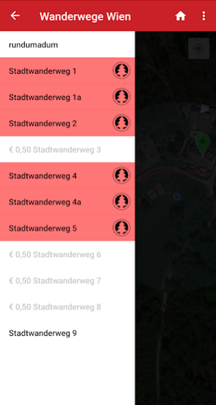
Rundumadum - circular route divided into 24 easily manageable stages
City hiking trail 1 - Kahlenberg
City hiking trail 1a - Leopoldsberg
City hiking trail 2 - Hermannskogel
City hiking trail 3 - Hameau
Stadtwanderweg 4 - Jubilee Observatory
City hiking trail 4a - Ottakring
City hiking trail 5 - Bisamberg
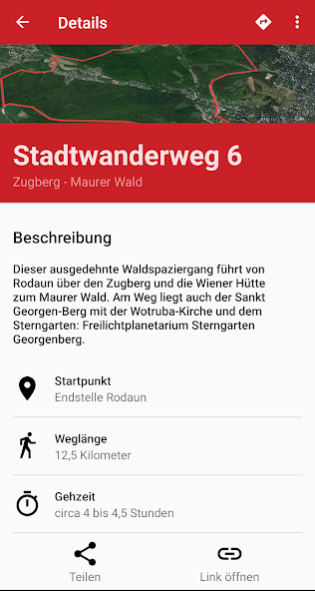
City hiking trail 6 - Zugberg-Maurer Wald
City hiking trail 7 - Laaer Berg
City hiking trail 8 - Sofienalpe
City hiking trail 9 - Prater
City hiking trail 10 - Franz-Karl-Effenberg-trail
City hiking trail 11 - Urbaner Gemeindebau
Main functions:
* The Wiener Stadtwanderwege and the "all around" path are displayed on the map.
* The stamp stations are marked on the map.
* Notification when a stamping point is reached, even if the app is in the background
* Stamps can be collected near the stamp locations.
* You can show and hide all paths individually.
* The current position is displayed.
* You can choose between satellite or map view.
City walk 1, 4 and 9 are included free of charge.
* The remaining routes can be purchased individually or all at once in the app.
* Hiking mode in which the map follows your current position
If you have questions, you can contact
[email protected] at any time.
Previous Versions
Here you can find the changelog of City hiking paths since it was posted on our website on 2019-11-06 12:59:07.
The latest version is 4.19.1 and it was updated on 2024-04-23 10:18:58. See below the changes in each version.
City hiking paths version 4.19.1
Updated At: 2022-08-22
Changes: Hiking trail 12
City hiking paths version 4.18.1
Updated At: 2022-02-02
Changes: Adjustments for Android 12
City hiking paths version 4.16.0
Updated At: 2021-01-27
Changes: Stability improvements
City hiking paths version 4.15.0
Updated At: 2020-12-25
City hiking paths version 4.8.0
Updated At: 2019-11-13
Changes: The stamp stations are shown on the map.
City hiking paths version 4.7.3
Updated At: 2019-06-04
Changes: Now also in English.
Disclaimer
Official Google Play Link
We do not host City hiking paths on our servers. We did not scan it for viruses, adware, spyware or other type of malware. This app is hosted by Google and passed their terms and conditions to be listed there. We recommend caution when installing it.
The Google Play link for City hiking paths is provided to you by apps112.com without any warranties, representations or guarantees of any kind, so access it at your own risk.
If you have questions regarding this particular app contact the publisher directly. For questions about the functionalities of apps112.com contact us.